
Landslide Detection Algorithm Achieves 80-94% Accuracy
Indian researchers have created an algorithm that provides a 80-94% accuracy in identifying landslide movement. This new algorithm is bound to help numerous Indians living in landslide prone areas.

- Indian researchers have created an algorithm that provides a 80-94% accuracy in identifying landslide movement.
- The algorithm does not predict landslides, but it gives necessary information to those who are in the business of predicting landslides, like what caused the landslide and what the mechanisms were.
- Current predictive models categorise different subtypes of landslides into a single group. This new method creates a comprehensive algorithm that tailors a mitigation approach based on the subtype to reduce uncertainty and bias.
In 2013, torrential rainfall in Uttarakhand caused devastating landslides and flash floods, leaving an unclear death toll in its wake. Last year, heavy rain and landslides killed at least 72 people in a single week in August in Himachal Pradesh. Deaths and monetary damages from landslides continue to occur around the world and in India as well. One statistic estimates that between 2010 and 2021, at least 3,710 people in India lost their lives to landslides, while tens of thousands of people were impacted in other ways.
Kamal Rana, a Ph.D. student at the Rochester Institute of Technology (RIT) grew up in the Indian Himalayas and experienced his fair share of landslides. “I’ve seen how landslides blocked roads, caused human and wildlife loss, and affected our ability to connect villages and cities in the Himalayas,” says Rana. “As a child, I was not able to understand landslides, but I learned that this phenomenon can be mitigated.”
Rana and Kushanav Bhuyan, a Ph.D. researcher from the University of Padova’s Machine Intelligence and Slope Stability Laboratory, along with a team of researchers, have created an algorithm that offers 80-94% accuracy in identifying landslide movements around the world.
This study introduces a new method of examining slides, flows, and fails, which are the different manners in which landslides occur, as well as finding distinct patterns of landslides that were previously unidentifiable. Their algorithm does not predict landslides, but it gives necessary information, such as causes and mechanisms, to those who are in the business of predicting landslides.
“It makes it way easier to understand what type of landslides are going to occur in the future as [the type] really defines the mitigation measures,” says Bhuyan.
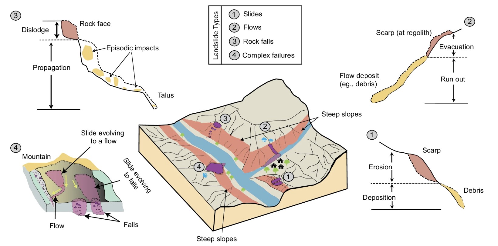
Different types of landslides display unique properties and require tailored mitigation measures. However, current predictive models do not take this into consideration. For example, “mudflow [landslides] exhibit visco-plastic or viscous/fluid kinematics caused by excess pore water pressure, while rock fall [landslides] entail the free falling of fragmented rocks from steep slopes,” writes Bhuyan in the study.
Each landslide type requires a unique solution, whereas current predictive models combine these different types into one group, making them carry significant levels of uncertainty and bias, especially when scaling up from a local level to regional and global levels.
Categorising them separately “requires comprehensive surveys (both in the field and remotely) and standardised classification protocols, which are laborious and time-consuming,” stated the study. But the team did the work of classifying landslides into their different subtypes, tested it on their algorithm, and achieved an accuracy of 80-94% depending on the region.
Previous attempts have been made at implementing different landslide subtypes in predictive models through knowledge-driven and data-driven approaches.
In the village of Giddapahar in Darjeeling, West Bengal, a bottom-up, community driven approach of measuring rainfall is being used. Members of the local community measure rainfall and when it reaches a certain threshold, they share the information with the Geological Survey of India (GSI) for timely action. However, this kind of solution is region-specific and works best on a local scale.
Data-driven approaches do exist, but they have looked at landslides in a two-dimensional lens, and in reality, landslides are three-dimensional phenomena, which make any two-dimensional approach limited. By using aerial view and the elevation data of landslide sites, combined with machine learning, the team was able to create three-dimensional landslide data, giving predictive modelers a stronger foundation to build their model on.

Data gaps in studying Indian landslides
The team based their research on many countries that are susceptible to landslides, including the United States, Italy, Denmark, Turkey and China, to boost the strength of their findings.
“One limitation is transferability. [Our algorithm] will work for the regions on which we have trained it on, but it won’t work for the regions on which we haven’t,” says Nishant Malik, an assistant professor in RIT’s School of Mathematics and Statistics who also worked on the algorithm.
India was notably missing in their sample of countries as the team said that Indian landslide data is sometimes inaccessible and incomplete, which can skew a predictive model. Bhuyan says that the accessibility to data is improving, but at the time of their study, they did not have access to it.
They hope that this paper will allow them to collaborate with agencies like GSI and the National Remote Sensing Centre (NRSC) so that their algorithm and predictive models can reach their full potential.
However, a lack of crucial data is not just a problem in India. Many countries do not have freely accessible, well-documented landslide datasets.
Although there is still work to do in making landslide data more accessible and detailed, this algorithm could be a step in the advancement of landslide predictive modelling.
This article first appeared on Mongabay. Here is the original link to the source.
Dive deeper with The Probe. For thoughtful analysis and in-depth stories directly to your phone, join our WhatsApp channel. Click and Connect with us Today: [WhatsApp Channel Link] 🔗
At The Probe, our commitment to social impact journalism is at the core of everything we do. Funded by well-meaning individuals from the public, our aim is to drive positive social change and make a real-world impact through the stories we report.
If you wish to support us, please visit our Truth Brigade page and contribute to a cause that resonates with you the most. It is through your support that we have been able to keep the flame of our journalism alive in these difficult times. Click link to support us to make a difference: https://theprobe.in/truth-brigade